


 Snowfall on Pitlochrie cottages, Barkly East, Eastern Cape, 10 June 2025. (Photo: Supplied)
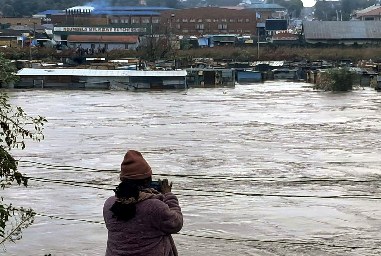
A powerful winter storm has swept across much of South Africa, bringing bitter cold, heavy rain, and snow to several provinces. The Eastern Cape is bearing the brunt, with the South African Weather Service (Saws) warning of a high risk of severe flooding, dangerous travel conditions, and closed roads.
What’s behind the severe weather? The culprit is a “cut-off low” — a weather system where very cold air becomes trapped and spins above the country, separated from the usual westerly winds.
Meteorologist Annette Botha from Vox Weather explains that this system is unusually deep, stretching from the upper atmosphere all the way to the ground — a setup more common in winter, and one that brings especially intense cold, rain, and snow.
“These ‘deep’ cut-off lows bring more intense and widespread weather impacts than the ‘shallow’ ones we often see in summer,” Botha said.
Weather warnings escalated in Eastern Cape
On Tuesday morning, 10 June 2025, Saws escalated the impact warning for the Eastern Cape to Orange Level 9, valid until 6pm, for severe impacts including widespread flooding, road disruptions, and reduced visibility.
 Snow fell on 9 June 2025 in the Eastern and Northern Cape in South Africa. (Photo: Africa View Facts / X)
 Snowfall in the Eastern and Northern Cape. (Photo: Africa View Facts / X)
 Mountain Shadows Hotel in the Eastern Cape on 9 June 2025. (Photo: Small Towns and Country Roads / Facebook)
 Barkly Pass in the Eastern Cape. (Photo: Storm Report SA)
 Barkly Pass on 9 June 2025. (Photo: Storm Report SA)
 Snowfall on Pitlochrie cottages, Barkly East, Eastern Cape, on 10 June 2025. (Photo: Supplied)
Saws meteorologist and forecaster Lehlohonolo Thobela noted that the cut-off low was expected to persist over the interior, bringing heavy showers and thundershowers, with possible flooding especially over OR Tambo District Municipality. Areas affected include King Sabata Dalindyebo, Mhlontlo, Nyandeni, and Port St Johns.
Impacts include:
- Widespread flooding of roads and settlements.
- Danger to life due to fast-flowing streams/deep water.
- Widespread transport routes and travel services severely affected.
- Widespread, prolonged disruption to essential services like water, electricity, communities and schools.
What’s in store for the rest of the country
A significant and dramatic drop in daytime temperatures can be expected over all provinces, with the possible exception of Limpopo.
The Department of Agriculture strongly advises farmers of small stock to implement appropriate measures to prevent stock losses due to exposure to bitter cold and wind.
- Gauteng: Isolated rain and showers are expected, particularly in the southern part of the province, with a possibility of sleet. Cold temperatures are expected to continue into the afternoon.
- Free State: Saws forecasts a 30% chance of rain and showers for the central and eastern parts of the Free State. Disruptive snow is expected over the southern and extreme eastern parts of the province.
- KwaZulu-Natal and Eastern Cape: There is a scattered to widespread chance of rain and showers, mainly over the Eastern Cape and southern KwaZulu-Natal. Disruptive snowfall is expected, especially over the escarpments of the Eastern Cape into the Drakensberg mountains (leading to Lesotho) and the extreme southern parts of KwaZulu-Natal. Disruptive rain is anticipated along the east coast of the Eastern Cape and into the adjacent interior. Damaging winds and waves are expected along the east coast into the interior of KwaZulu-Natal and the eastern half of the Eastern Cape, which may make navigation at sea and in the interior difficult.
As for tomorrow, Thobela forecasts that: “Isolated rain and showers are expected along the east coast of the Eastern Cape, with the possibility of damaging interior winds over the eastern half of the Eastern Cape into the eastern parts of KwaZulu-Natal, and damaging winds and waves are still expected along the east coast, which might result in navigation at sea being difficult.”
Safety Advice and Road Closures
Given the severe weather conditions, Saws and local authorities urge the public to exercise extreme caution.
Residents are advised to listen for regular weather updates via radio and social media, postpone travel plans until conditions improve, and avoid crossing rivers and swollen streams. It is also recommended that people secure valuable items from potential floodwaters.
WATCH: Due to the snow, the N2 near Kokstad in southern KwaZulu-Natal is closed. pic.twitter.com/St5oFY5a61
— Sihle Mavuso (@ZANewsFlash) June 10, 2025
Several roads affected by snow and adverse weather
Eastern Cape:
- N2 between KwaBhaca (Mt Frere) and Kokstad is facing imminent closure due to thick snow.
- N9 at Lootsberg Pass near Middleburg towards Graaff-Reinet: Traffic is moving slowly under strict supervision.
- R61 at Wapadsberg Pass near Graaff-Reinet towards Nxuba: Traffic is moving slowly with strict traffic officer control.
- R58 at Barkley Pass near Elliot towards Barkley East: Heavy snow continues, road is open only to small cars under strict supervision.
- N6 at Penhoek Pass near Queenstown towards Jamestown: The road is open despite snowing conditions.
- R58 from Lady Grey towards Barkley East: No snow reported so far.
While mountain passes in the Eastern Cape remain snow covered, they are open, according to Department of Transport spokesperson Unathi Binqose. However, heavy-duty vehicles are currently restricted from using Barclay Pass (R58), Wabersberg Pass, and Lootsberg Pass (N9).
“We are monitoring the situation as it changes moment by moment,” Binqose added.
KwaZulu-Natal:
- The N2 is closed from Ingeli to the Kokstad triangle and from the Kokstad triangle to Brooksnek due to heavy snow.
- The N2 between Kokstad and Pietermaritzburg is also closed.
- The R603 between Tacoma and Reit is closed.
- The N2 Stafford Post near Umzimkhulu is closed after motorists tried to drive through snowy conditions.
- Rain and strong winds affect the N2 routes towards Port Edward and Harding, with crews clearing fallen trees.
Despite icy winds and scattered snow in the Drakensberg, roads in northern municipalities like Amajuba and Uthukela remain open. Patrol teams are actively monitoring routes, and road rehabilitation crews are responding to hazards such as fallen trees.
KwaZulu-Natal MEC for Transport and Human Settlements, Siboniso Duma, urged motorists to avoid closed routes and adhere to traffic rules. In Mbhashe Local Municipality, residents are advised to avoid crossing rivers, overflowing streams, or low-lying bridges and to stay indoors unless absolutely necessary while monitoring weather updates.
Humanitarian support mobilised
In response to the escalating crisis, humanitarian organisation Gift of the Givers has activated its disaster response team. The group is providing emergency relief — including food and blankets — in Butterworth and surrounding areas where community halls have been opened to shelter displaced families.
The Amathole District Disaster Management Team and Mnquma Local Municipality requested immediate assistance after floods caused large-scale evacuations. DM
For real-time updates, follow Saws on X (@SAWeatherServic) and Facebook (South African Weather Service) or visit www.weathersa.co.za.
For USSD alerts, dial 1207297# for weather warnings. Or download the WeatherSMART app for Apple and Android phones.