


 Palaeoanthropologist Jan de Vynck explaining a giant zebra print. (Photo: Don Pinnock)
In the search for our past, there’s something almost magical about a fossil footprint. It’s not a gnawed bone in a cave, a stone tool or a bleached skull staring eyelessly, it’s the imprint of a living creature — or person — who stood in that place at that moment thousands of years ago. And they were everywhere we looked.
But I’m getting ahead of myself. The journey really begins in a single room of a small museum in Still Bay on the Cape South Coast. Crowding around paleoanthropologist Jan De Vynck are two lawyers, a publisher, a doctor, two NGO workers, myself and three Ju/’hoansi San trackers from Namibia. In glass cases are stone tools, bones and a piece of inscribed red ochre acknowledged as among the oldest artwork made by fully modern humans.
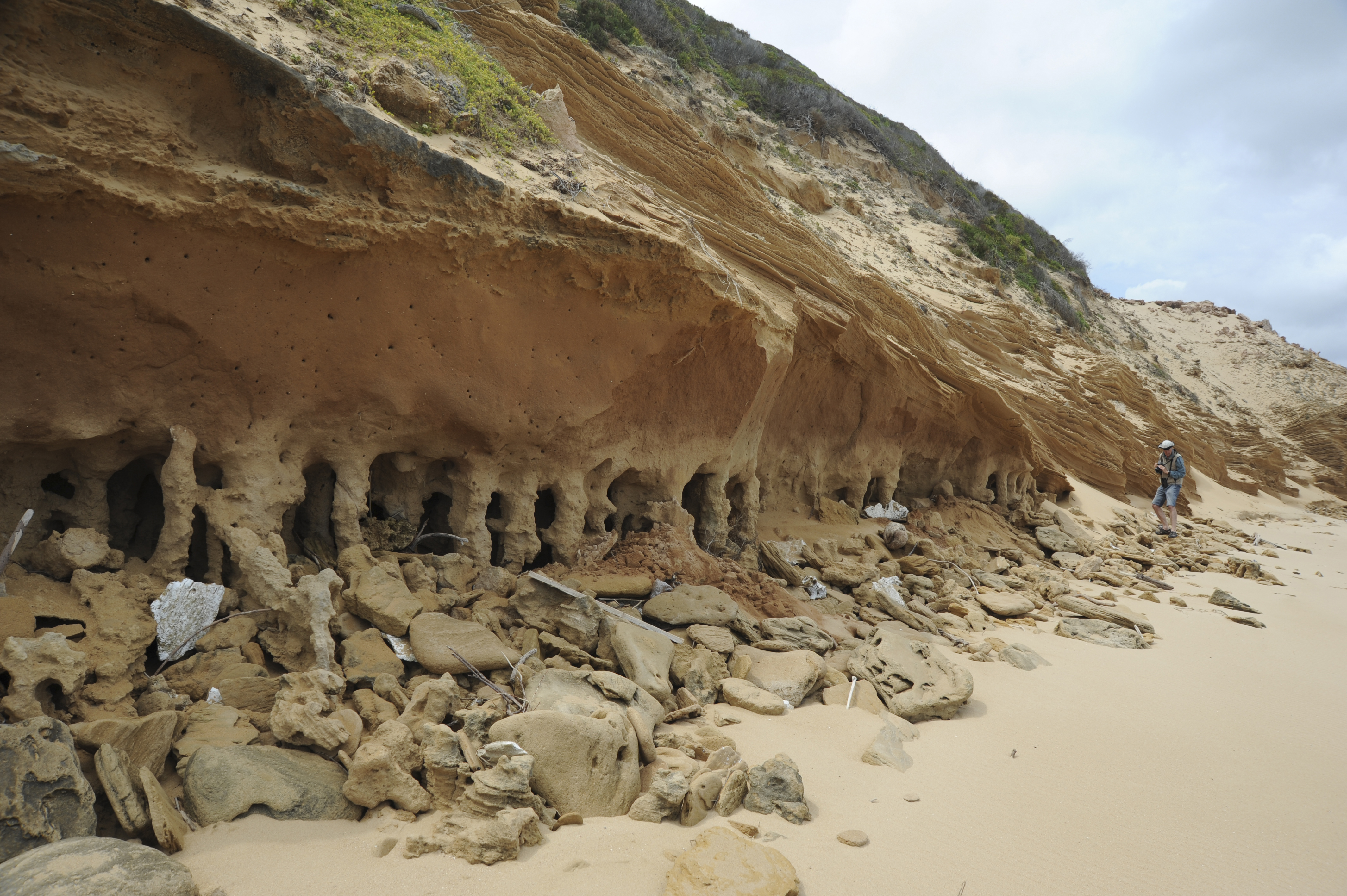
De Vynck is explaining what we’re about to do. Lining the beach below are very strange-looking cliffs which, under pounding waves, are delaminating layer by layer. Each layer was once the surface of a dune and on them creatures walked and left their prints. Countless steps and countless showers over ever-changing dunes have left their mark.
 A cave formed by delaminating aeolianite. (Photo: Don Pinnock)
But there’s a problem. The fragile compacted sand layers, known as aeolianite, are deteriorating under wave and wind action.
The citizen scientist team has been assembled by lawyer and wilderness trail guide Clive Thompson to help De Vynck capture and document tracks before they die. The research is in collaboration with primary investigator Dr Charles Helm who’s in Canada and can’t join us.
Thompson has brought in the best people on Earth to help: indigenous Ju/’hoansi master trackers Steven Kxunta, /uce Nǂamce and #oma Daqm from Nyae Nyae in Namibia. Who better to read 100,000-year-old trackways?
We assemble on the beach the next morning. The Ju/’hoansi are not looking at the cliffs but gazing at the sea. “What makes the waves? Whales?” No, the wind. Much discussion follows in an ancient language sprinkled with pops and clicks.
For the rest of the team, though, the cliffs are riveting. In oranges, reds and blacks set at all angles are stacked layers penetrated here and there by shallow caves. It’s the weirdest rock wall I’ve ever seen.
The aeolianite dunes, it turns out, are encoded time stamps. A series of bedding planes — say 20cm high — may have been laid down in the distant past over just a few days or weeks or 10,000 years, depending on wind flows and erosive forces. In them are enigmatic prints.
But it’s time to stop gawping. De Vynck needs to give us a lesson on how to see.
“This is an elephant footprint,” he says, pointing to a large teardrop shape on the cliff wall.
No way!
“Yes, you have to think differently, he says. “You’re looking at it from the side and half has broken away. It slid down the dune slope, then got purchase. Its weight compressed the sand. Then, later, sand blew into the footprint, but the compacted sand held the shape.”
Further down the beach, it’s a lesson in upside-down prints. A heavy hoof or paw depressed the sand below it, but when the layers delaminate, the impression stays with the upper layer, so you’re looking at a print from below, which is called a convex infill cast. The trackers are fascinated and much discussion follows.
https://www.youtube.com/watch?v=5PO6EwEidpw
Tracks everywhere
But, slowly, we’re getting it. Then, real excitement: a clear set of prints across a curving surface. The Ju/’hoansi huddle, peer at the tracks from various angles then pronounce: “Very big buffalo. Deep track.” Turns out they’re spot-on. There was a huge, long-horned buffalo but it’s now extinct.
After a while we’re almost hallucinating tracks. Every dent or protrusion is inspected and debated. This is exciting stuff. Lion, rhino, giant zebra and giant buffalo, an aardvark burrow, mole rat tunnels, bird tracks — the cliffs are coming alive.
One of the biggest questions people ask, says De Vynck, is how these tracks get preserved. If you walk on a beach, those tracks are gone by the next day. Most of the trackways we saw were between dunes where the sand remains moist after rain, preserving the tracks.
“Over time, dry sand from surrounding dunes blows over and covers these tracks, creating layers of preservation. Rain percolates through the dune and dissolves minerals which cements them into rock.”
Instruction period over, the next day we drive along the coast to a spectacular and completely deserted beach for the real thing. Who could have imagined such a pristine wilderness along this coast?
The trackers are in their stride and we’re following in their wake. Now and then, though, they stop and gaze at the sea — it’s just not something you get in northeastern Namibia. The rest of us are hooked on paleoanthropology. Are we about to find Homo sapiens tracks, the holy grail of this mission? How did the people who made them live, what did they eat?
For Steven Kxunta, the man from Nyae Nyae, it’s obvious: “I think the people who lived here thousands of years ago were living like my people. We gather roots, bulbs and nuts, hunt game with traditional weapons. These people who were here and my people, we are connected.”
![]() Steven Kxunta. (Photo: Don Pinnock)
Steven Kxunta. (Photo: Don Pinnock)
“The Ju/’hoansi are perhaps the last of the San of the greater Kalahari in central southern Africa who retain and deploy the full suite of their ancient hunter-gatherer skills. They speak their original striking click language, they have access to (some of) their original country, their lands are still largely wild, with free-roaming small and large game, their bush communities still engage in subsistence hunting with bow and poisoned arrow, they gather food from the veld and still draw on their healing dances. A few among them still hunt by persistence running. They are the keepers of prehistoric lore and rare exponents of the art of tracking. Their ability to follow game tracks — offering riveting interpretations of animal behaviour along the way — is the stuff of legends.” (Clive Thompson – Ju/’hoansi Trackers Association information sheet)
The trackers’ brief visit is intended as a test of concept and we seem to be proving that concept. They can read ancient trackways.
There’s something hugely fitting about the subcontinent’s earliest hunter-gatherers exploring the tip of Africa to help uncover traces of their and our origins as well as traces of Africa’s other creatures, some still with us, some gone forever.
But something isn’t making sense. Buffalo, giraffe, rhino, hippo, quagga, lion, hyena, springbok all managing to survive on coastal fynbos? When I voice this, De Vynck gives me a puzzled look, then says: “They lived there.” He’s pointing at the sea, which is noisily chewing bits off the land. Then he explains.
 Palaeoanthropologist Jan de Vynck explaining a giant zebra print. (Photo: Don Pinnock)
Ice ages are climate change on steroids. Ice eats water, seashores retreat significantly across the planet and huge areas desertify. The Quaternary Ice Age kicked in around 2.58 million years ago with wild fluctuations between warm and freezing periods.
For most of the time our species was developing, the ice caps covered large parts of Europe and North America. Inland would have been deserts and living there was near impossible, so the coastal areas were their salvation. But they weren’t the coasts we have today.
“Standing here 100,000 years ago you wouldn’t see the sea,” he says. “It was up to 47 metres lower than today. What you’d be looking at would be the equivalent of the Serengeti: meandering rivers, grassland, elephants, giraffes, buffalo, antelope, predators. It’s called the Palaeo-Agulhas Plain. Climate change drowned the plain and evicted the animal species living there.”
Scientists have recently been reconstructing conditions on the Palaeo-Agulhas Plain and the result is astonishing. At its extent it added an area of around 84,000km2 to the Southern Cape — roughly the size of Ireland.
It’s generally assumed that ice ages meant harsh times for hunter-gatherers, but the Cape South Coast was an outlier, a refuge within which our pre-human ancestors evolved into Homo sapiens.
Rich record
“The Paleo-Agulhas Plain had regular water, woodlands and flat areas, perfect for hunting,” De Vynck continues. But maybe even more importantly it had a coastline with mussels, limpets, alikreukel and periwinkles. Superfood.
“The glacial period between about 80,000 and 57,000 years ago was of extraordinary importance to early modern humans and has left us with one of the richest records of modern human origins.”
Warmer interglacial periods were bad news because the seas rose and flooded the plain. People and animals would have had to retreat with the rising seas that swallowed their hunting grounds.
At times the small proto-human then human population bottlenecked and may have come close to extinction. But for most of the 2.6 million years of the Pleistocene (it ended 12,000 years ago), the world was in the grip of ice and the Paleo-Agulhas Plain throbbed with life. Humans made composite tools, possibly traded goods and, evidence tells us, made art.
We stare at the sea, trying to imagine a Serengeti or Karoo beneath the water. The enormity of climate change that inundated it is impossible to visualise. In a hundred, a thousand years, will our hunger for CO2-emitting fossil fuels drown this beach? Or will another ice age chase the sea over the horizon? In the rhythms of the planet, we live in such a tiny slice of time.
That evening De Vynck surveys the eager group speculatively and decides we’re up to it: “Tomorrow we’ve got a hike. Blombos Cave. You guys manage that?” In the absence of knowledge about what that will entail, we nod eagerly. DM
This expedition was supported by the Discovery Wilderness Trust.
Read Part 2: Blombos Cave and the birth of intelligence
Understanding ice ages
The Earth is a living thing that can catch cold or fever and scientists have been trying to work out why. During the Pleistocene, ice sheets grew then shrank, and sea levels rose and fell. The most plausible explanation is known as Milankovitch Climate Cycles, named after a Serbian scientist who worked it out. They’re thought to be the main drivers of glacial and inter-glacial periods.
- Every 100,000 years or so the Earth’s orbit round the Sun changes from more circular to more elliptical, causing a reduction of solar warming at the furthest points.
- About every 41,000 years the Earth’s axis tilts, varying between about 22° and 24°, affecting the intensity of seasons and the distribution of warmth on the planet, and
- Every 26,000 years or so the Earth’s rotation wobbles, causing a shift in seasons.
-
At times, these forces work together to create ice ages. DM