


 (Image: National Weather Service)
 A rip current forecast system has been launched to help safeguard Cape Peninsula beaches this festive season, providing daily forecasts that indicate when rip currents are likely to occur.
According to the South African Weather Service (Saws), rip currents cause more than 100 deaths in SA a year and are linked to 10,000 drownings globally every year.
Lebogang Makgati, a senior marine services manager at Saws, said: “We’ve never issued the current alerts before and based on this model we are now able to alert communities and emergency responders about the currents that are strong.”
The model will provide forecasts for six beaches: Blouberg Beach, Milnerton Beach, Fish Hoek Beach, Monwabisi Beach, Strand Beach and Kogel Bay Beach.
According to Saws, the six locations were selected based on the high number of rip current incidents recorded during the model development phase. Saws cautioned that rip currents can still occur at other beaches in the Cape Peninsula.
In 2022, the City of Cape Town reported that there had been 56 drownings at public beaches and swimming pools during the peak summer seasons in the city since 2019.
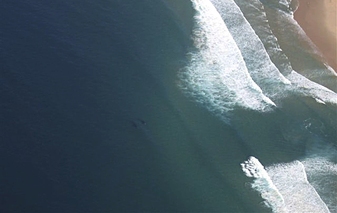
Rip currents
Rip currents are powerful narrow channels of fast-moving water that flow from the shore out to the open sea.
“Rip currents form when water that has been pushed toward the shore by waves and wind gathers and finds a path back out to deeper water, typically through a break in sandbars or other underwater features,” said Makgati.
In August 2024, Medhi Narjissi (17), a member of the French Under-18 rugby team on tour in South Africa died after he was caught in a strong rip current at Diaz Beach, Cape Point.
Read more: Touring French U18 rugby player is presumed drowned off Cape Point
Lead Saws marine scientist Dr Ramontsheng Rapolaki said the forecasts for the six beaches were valid for three days and would be updated timeously.
 Dr. Ramontsheng Rapolaki. (Photo: Siyabonga Goni)
The forecast system uses modelled wind, wave and tidal data from the Saws Marine Model to evaluate the potential for rip current formation.
“There are different colour codes and symbols that are used to communicate the forecast. Green will represent Level 1, low risk that indicates that the risks are unlikely to occur. Yellow, Level 2, medium risk, that indicates that there’s a likelihood of occurrence. Red, Level 3 high risk, there's a strong likelihood [of rip currents]. Black, Level 4, to communicate the occurrence of high winds and strong currents,” said Rapolaki.
Creating the system
Scientist Carla Ramjukadh, who appeared virtually at the press briefing on the launch of the model, said the development of the forecast system started in 2019/2020.
“Due to the Covid-19 pandemic, the project had a gap. Even though the project was only for a year, fieldwork and field developments could only take place once Covid-19 restrictions were lifted. There was also a delay in acquiring the necessary software infrastructure for the Saws to run the model operationally,” said Ramjukadh.
The creation of the system required rip current incident data, which was provided by Lifesaving South Africa, the City of Cape Town and the National Sea Rescue Institute.
Other requirements included beach-type information that was gathered by Stellenbosch University and the South African Environmental Observation Network. The Coastal Marine Applied Research consultancy at the University of Plymouth in the UK also worked on the model.
 (Image: National Weather Service)
Lifesaving South Africa director Melvyn Shaw said the new forecasting system would help to save lives.
Saws said it aimed to expand the system to other areas including the southwest coast and Natal coast.
The system will be implemented in the coming weeks when it can be accessed at the Saws Marine Portal. DM