


 Sanae IV, the South African research station in East Antarctica, is built on the edge of the Vesleskarvet rocky outcrop or “nunatak”. (Photo: Tiara Walters)
‘Bret Flat Earth Bible Jesus” has a message for you: The flat-topped mountain peak hosting South Africa’s scientific research station is a “giant tree stump”.
“Giant Tree stump in Antarctica from before the Flood when this terrarium’s climate was different?” they suggest, according to a video posted on 17 February. Their hypothesis has been posted more than 350 times and has attracted nearly 500 comments.
“The Angels,” said the account, while citing Daniel 4:11-14, “cut them down.”
Since it is unclear who “them” might be, we consulted the New International Version of the English Bible, but found ourselves stumped. We also could not find evidence to suggest God’s diplomatic envoys had been dispatched to Antarctica to cut things down.

A digitally altered video posted on Bret Flat Earth Bible Jesus’ Threads account. (Image: Screenshot)
Even if Bret Flat Earth Bible Jesus was talking about a tree stump, the quoted Bible passage is, to be more exact, about every self-respecting stump’s nightmare: an actual tree.
“The tree grew large and strong and its top touched the sky; it was visible to the ends of the earth,” says the passage.
Daily Maverick also understands King Nebuchadnezzar — the Babylonian dynasty’s longest-reigning king — was tripping when he saw this luridly large tree.
But Daniel, summoned by the king to interpret his dream, intervened with timely tips: praise God, be nice to people … and a big tree — not a stump — you shall remain.
We digress.
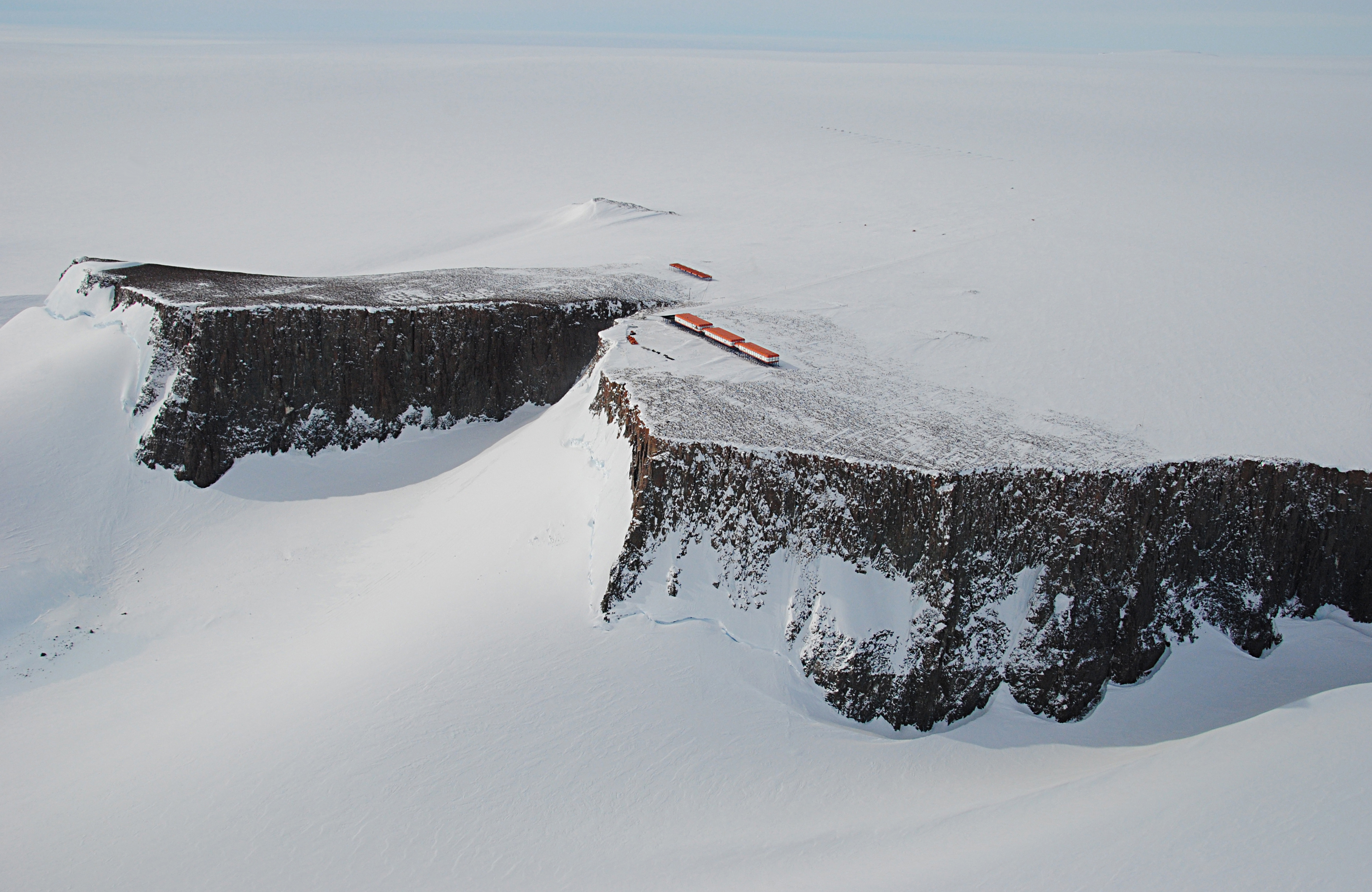
The so-called giant stump that has social media abuzz is, in fact, a rocky outcrop that serves as the setting for Sanae IV, South Africa’s scientific research station in Queen Maud Land, East Antarctica.
Designed by the engineer Hennie Stassen, Sanae IV (the South African National Antarctic Expedition) is the country’s fourth research station.
 Freeing snowmobiles from snow build-up at Sanae IV. (Photo: Tiara Walters)
Unveiled on stilts at the dramatic edge of a cliff in 1997, Sanae IV is based 170km from the ice shelf, at 72°40' S, 2°50' W, and remains among the minority of research stations built deep inland.
Thanks to an advanced design allowing snow and ice to blow through its legs, it is the first South African station not to be swallowed by the ice shelf — a fate widely shared by other states’ stations. It houses year-round and seasonal researchers specialising in meteorological, geological, biological and other scientific studies.
In other words, Bret Flat Earth Bible Jesus’ claim is fake.
South Africa is one of 12 founding signatories of the 1959 Antarctic Treaty, which devotes the continent and surrounding ocean to peaceful activities like science and tourism.
Since this theory has a habit of resurfacing in some form or another every few years — Reuters debunked a similar one in 2021 — we asked South Africa’s long-suffering polar authorities at the Department of Forestry, Fisheries and the Environment.
The department acknowledged our queries, but did not respond to questions by the time of publication of this article.
Professor Ian Meiklejohn, of Rhodes University’s geography department, explained that Sanae IV is built on a “nunatak”.
“A ‘nunatak’ is an Inuit name (nunataq) for an island of rock that protrudes from an icefield, glacier or snowfield,” says Meiklejohn, who specialises in the landscape processes of Antarctic ecosystems. “They are the summits, or summit areas, of mountains or high-lying ground that protrude above the ice and are sometimes called glacial islands.”
The South African nunatak appears in Norwegian-claimed territory neither denied nor recognised by the treaty. The nunatak, says Meiklejohn, was mapped by Norwegian cartographers from surveys and air photos in the 1940s and 1950s, who named it “Vesleskarvet” (“little barren mountain”).
“Vesleskarvet is one such nunatak that is a small part of a Precambrian dolerite sill that is around a billion years old. Dolerite is a volcanic rock that is found in sills, which are horizontal; and dykes, which are vertical or inclined intrusions of lava.
 Snowmobiles and rescue climbing gear in front of Sanae IV in Queen Maud Land, East Antarctica. (Photo: Tiara Walters)
“Similar, but much younger” dolerite lava intrusions of about 180 million years old form the mesas, buttes and koppies that define South Africa’s Karoo landscape, he points out.
“By examining the ice topography, the sill on which Vesleskarvet is found forms an escarpment that is at least 50km long. It currently protrudes up to 160m from the surrounding ice at Sanae IV.”
Bret Flat Earth Bible Jesus did not respond to a request for comment. DM
Tiara Walters is a Daily Maverick journalist with a special interest in Antarctica. She spent a summer at Sanae IV during the 2009/10 season. Walters notes that, while after-hours alcohol was served at the station bar, no occupants reported visions of living on a giant tree stump.